As if plucked from a whimsical fairytale and set down upon the stark Anatolian plains, Cappadocia is a geological oddity of honeycombed hills and towering boulders of otherworldly beauty. The fantastical topography is matched by the human history here. People have long utilised the region’s soft stone, seeking shelter under ground and leaving the countryside scattered with fascinating cavern architecture. The fresco-adorned rock-cut churches of Göreme Open-Air Museum and the subterranean refuges of Derinkuyu and Kaymaklı are the most famous sights, while simply bedding down in one of Cappadocia’s cave hotels is an experience in 21st-century cave living.
Khepatukha, meaning “the country of the people of the chief god Hepat”, although there are more poetic claims on the origin of the region’s name, such as the Old Persian Katpatuka, which allegedly means “the land of beautiful horses”. The tablets called Cappadocian Tablets and the Hittite works of art in Alisar are of the important remains dating from 2000s B.C.
ÜRGÜP
Located 20 km to the east of Nevşehir, Ürgüp is among the most important centers of Cappadocia. It has had numerous different names in the course of its history because of hosting many different civilizations. It has been called Osiana (Assiana) and Hagios Prokopios during the Byzantine Period, Başhisar during the Seljuk Period, Burgut Castle during the Ottoman Empire period and beginning from the first years of Turkish Republic, it has been called as Ürgüp.
Ürgüp, having a volcano originated geologic structure, was established on a region where the typical samples of the interesting natural formations, originated from the rain and wind erosions and called as chimney rock (fairy chimneys), are situated. The chimney rocks, formed from the rainwaters flowing from the valley sides and afterwards wind erosion, created a very interesting landscape view pertaining to the region.
Being an important religious center also during the Byzantine Period, Ürgüp was the episcopacy center of rock churches and monasteries in the villages, towns and valleys.
GÖREME
Göreme always attracts historicians and travellers during centuries with its natural beauty and cultural affluence. Cappadocia was named as Katpatuka in Persian period. That meant the area that good horses were raised. Nevertheless, it is still argued that the name belongs to Hatti, Luvids, Hittites or Assyrians. For this reason, horses and horse raising have been investigated and important veri has been taken.
Göreme which have the old names of Korama, Matiana and Maccan is 10 km far away from the center of Nevsehir province. The valley created from volcanic rocks is famous with the chimney rocks resulting from the erosion made by the natural factors to these rocks and with the historical richness. It has been an important religious place together with the intensive emigration of the first Christians escaping from the pressure of the Roman soldiers. The population escaped from the pressures has made many abbeys, churches and houses in the volcanic rocks from the valley where they were able to hidden easily. In our days in Goreme are found Elmali Church, Saint Barbara Church, Carikli Church, Tokali Church and Hidden Church and all of these are Goreme Open Air Museums. In the churches there are scenes from the life of Jesus, descriptions of the saints who written the Bible and pictures of Saint Barbara and Saint Georgius.
GÖREME OPEN AİR MUSEUM
Goreme Open Air Museum is a member of Unesco World Heritage List since 1984.
The most important works that illuminate the history f Christianity in Cappadocia are churches hollowed in rocks. There are more than two hundreds and fifty churches in the region. Also, churches and monasteries can be seen in all of the valleys. In this part of the site, the most important ones of them are going to be mentioned. The area that churches are commonly found is Göreme as religious centre that life of monasetery was come true between 3.and 8. centuries. For the architecture and decorations of the churches and chapels is as wides examples in Göreme Valley.
DEVRENT VALLEY
Devrent Valley, which is also known as Imaginary Valley and also as Pink Valley does not have cave churches like the other valleys of Cappadocia. There are no Roman castles or Roman tombs in Devrent Valley, either. Actually it was never inhabited. So what makes it so famous? The lunar landscape!
Devrent Valley (also spelled as Dervent Valley) reveals many different rock formations and is only a 10 minute drive from Goreme. The small fairy chimneys in the valley form a lunar landscape, or moonscape, by their strange look. The valley also has many animal shaped rocks. It looks like a sculpture zoo made by nature. Some of the most important, or the easiest seen animal shapes are camel, snake, seals, and dolphin. If you let your imagination run free you will find many others. It is like looking at clouds and seeing a dragon. There is even a rock pillar which looks like Virgin Mary, holding Jesus Christ.
IHLARA VALLEY
A Crossroads in the History of Christianity
The first settlements and initial structures were dated back into Roman era; however the Ihlara Canyon found its identity during the Byzantine period. Ihlara became an important religious centre during the early Christianity. Some of the churches of the canyon were from that early period of Christianity. The Ihlara Canyon was the learning ground for great theologians of the Early Christianity, such as Basil of Caesarea (also called Saint Basil the Great) and Gregory of Nazianzus. The monasteries and churches carved into tuff were adorned with historically significant frescoes depicting Biblical stories and lives of saints, painted with unmatched artistic mastery using natural dyes. For the early Christians building their places of worship into secluded areas was a very important prerequisite, and visitors of the Canyon would realise how Ihlara provided an ideal setting to cater that need. However, carving churches did not end at that era, and many churches have been carved and adorned with frescoes during the Byzantine era as well as long after the domination of the Seljuk Empire over the region. The Selime Monastery which is the largest monastery of Cappadocia Region is also there. Ihlara Canyon is a site where exceptional historical heritage such as those rock hewn churches that has arrived to our times almost intact could be visited.
Alongside the monasteries and churches carved from rock since the 4th century AD, there are carved dwellings in the Canyon, and the tradition of carving worshipping spaces out of rock has continued during the Byzantine era as well as during the Islamic domination of the region. The mosque of Ilusu town, where a Roman bridge and bathhouse could also be visited, is one of the prime examples of that centuries old tradition.
AVANOS
The town of Avanos is set on the banks of the Kizilirmak, the Red River. The town is about 8 kilometers (5 miles) from Goreme. Avanos has a lively center with all the usual amenities including a modern, tourist-oriented hamam (Turkish Bath).
In some of the abandoned houses the features of traditional Ottoman architecture can be seen along with ancient decorations, motifs and murals.
Red RiverThe Kizilirmak (red) river (ancient Halys river) is the longest river in Turkey and it does not only separate the town from other parts of Cappadocia, but also gives the supplies the clay for pottery. It is by this river that the red pottery clay is found from which Avanos derives its main livelihood and its foremost claim to fame. Pottery has been produced in the Avanos area for centuries and some of the techniques still used date back to Hittite times to 2000 BC. The Hittites named the town “Zu Wanes” and it became “Venessa” during the Eastern Roman (Byzantine) Empire.
Avanos is a mass of family run potteries. These famous potters make wonderful souvenirs and are available at a wide range of prices from simple ashtrays and mugs to ornate plates and chess sets.
About 14 kilometers (9 miles) from Avanos is the underground city of Ozkonak and the beautiful 13th century Seljuk caravanserai, Sarihan (where whirling dervishes ceremonies are performed each evening), is only about 3 kilometers (2 miles) from the town center.
On one of our Cappadocia Tours, we will see the demonstration of pottery by kick-wheel technique. Our guests can also try to make a pot.
Çavuşin (Nicephorus Phocas) Church
This church is located alongside Göreme-Avanos road at a distance of 2.5 km (1.6 mi) leaving from Göreme. The church’s narthex is missing. It has tunnel vaults, a high nave and 3 apses. It dates back to 964-965 AD.
UCHISAR
The fairy chimneys to the west, east and north of Uchisar were hollowed out and used as graves during the Roman period. Inside these rock cut tombs, the entrances which generally face west, are klines or stone slabs on which the bodies were laid.
Uchisar Pigeon Valley, Cappadocia Many rock cut churches have been discovered not only on the outskirts of the castle but also inside it. The reason for this may be that Goreme, having numerous churches and monasteries, is very close to Uchisar.
There are also many other pigeon houses in Pigeon Valley (Guvercinlik Vadisi in Turkish) which connects Uchisar to Goreme. Most of these cave dwellings have been painted white to attract the birds and their valuable droppings.
Uchisar Castle, CappadociaUchisar is situated at the highest point in Cappadocia, on the Nevsehir-Goreme road, just 5 km from Goreme. The top of the Uchisar Castle, provides a magnificent panorama of the surrounding area with Mount Erciyes in the distance.
PASABAG
Pasabag in Cappadocia is located on the road to Zelve, coming from Goreme or Avanos. Highly remarkable earth pillars can be seen here, in the middle of a vineyard, hence the name of the place which means: the Pacha’s vineyard. Pacha means “General”, the military rank, in Turkish and it is a very common nick name. This site is also called Monks Valley. The name was derived from some cones carved in tuff stones which stand apart. Currently, there is a vineyard and a number of tuff cones standing right next to the road.
Some of these cones split into smaller cones in their upper sections, in which stylites and hermits once hid. The hermitage of Simeon monks was also here. A chapel dedicated to St. Simeon (Simon), and a hermit’s shelter is built into one of the fairy chimneys with three heads. The entrance of the cell is decorated with antithetical crosses. Saint Simeon was living in seclusion near Aleppo in the 5th century, when rumors that he made miracles started to spread. Disturbed by all the attention, he began to live at the top of a 2m high column, and later moved to one 15m in height. From there he only descended occasionally to get food and drink brought by his disciples. The hermits of Cappadocia distanced themselves from the world by cutting into fairy chimneys rather than living on top of columns.Pasabag, Cappadocia They hollowed out the chimneys from bottom to top creating rooms at 10-15m high.
Pasabag valley contains some of the most striking fairy chimneys in Cappadocia with twin and even triple rock caps. This style is unique even for Cappadocia and these fairy chimneys are named mushroom-shaped fairy chimneys.
On one of our Cappadocia Tours, we visit Pasabag and see St. Simeon Church and mushroom shaped fairy chimneys.
GULSEHIR
Gulsehir is situated on the southern bank of the Red River (Kizilirmak) and in ancient times it was called “Zoropassos”. Later, during the Roman Empire the town was named as Arapsun. Modern Turkey names the city as Gulsehir which means Rose City.
Aciksaray (Open Palace):
15 km outside Nevsehir, on the Nevsehir-Gulsehir road (route 765), you will come across a deserted cave-village with rock-cut dwellings and chapels, to which the local inhabitants have quite recently given the name Aciksaray (Open Palace). The village is remarkable for its facades and the odd-looking formations, some resembling huge mushrooms, trees, even human faces.
Gulsehir, Aciksaray (Open Palace), CappadociaThis small settlement can be dated back to the 10th or 11th centuries. It covers an area of one square kilometer and contains eight complexes gathered around three-sided courtyards, each with a decorated main facade.
The first complex on the right when you enter Aciksaray from the Nevsehir-Gulsehir road has one of the best elaborate facade in Cappadocia. The complex has two irregular rooms and one rectangular, in which a large equal-armed cross is carved on the interior wall above the entrance. Their heads are lost, because a window-like opening has been cut on the wall. Only in Aciksaray, you will see the motif of the bull, regarded as sacred by the Neolithic communities in Anatolia as well as the Hittites.
St. Jean Church (Karsi Kilise):
The two floor church of St. Jean, found upon entering Gulsehir, houses a church, wine cellar, graves, water channels and living quarters on the lower floor, and a church decorated with Biblical scenes on the upper floor. According to the inscription on the apse, the church is dated to 1212.
St. Jean Church (Karsi Kilise) Frescoes, Gulsehir, CappadociaThe lower floor church is built to the shape of a cross, has one apse and arms of the cross are barrel-vaulted. The central dome is collapsed. Stylized animals, geometrical and crucifix designs are used to decorate the church in red ochre, which was applied directly onto the rock. The upper church has one apse, and is barrel-vaulted. Apart from those on the apse, the well-preserved frescoes were covered in a layer of black soot. The church’s present state is a result of the restoration and conservation done by Ridvan Isler in 1995.
Scenes from the life of Jesus and the Bible are in the form of friezes within the borders. Yellow and brown have been used on a black background. On the niche vault and on the sides, floral and geometrical patterns were used. On the west and south walls the Last Judgment can be found, a scene rarely depicted in Cappadocian churches.
DERINKUYU UNDERGROUND CİTY
These troglodyte cave-cities were excavated as early as Hittite times, and expanded over the centuries as various marauding armies traversed Central Anatolia in search of captives and plunder. There are 36 underground cities in Cappadocia and the deepest one is Derinkuyu underground city, while the widest is the Kaymakli Underground City.
The Derinkuyu underground city is located in the same named town Derinkuyu, which is situated 40km from Goreme (30 minute drive). There are about 600 outside doors to the city, hidden in the courtyards of surface dwellings. The underground city is approximately 85m deep. It contains all the usual rooms found in an underground city (stables, cellars, storage rooms, refectories, churches, wineries etc.) Apart from these, a large room with a barrel vaulted ceiling on the second floor was a missionary school, the rooms to the left being study rooms.
From the 3rd and 4th floors onwards the descent is by way of vertical staircases which lead to a cruciform plan church on the lowest floor.
It is unlikely that the underground cities were ever intended for permanent dwelling, or even long stays, but they were clearly built to withstand attack and could support large numbers of people and their domestic animals, for extended periods of time. The urban organization was very complex, and there was probably always work in progress.
Derinkuyu Underground CityThe extensive networks of passages, tunnels, stepped pits and inclined corridors link family rooms and communal spaces where people would meet, work and worship. The cities were complete with wells, chimneys for air circulation, niches for oil lamps, stores, water tanks, stables and areas where the dead could be placed until such time as conditions on the surface would allow their proper disposal. Most importantly, carefully balanced moving stone doors, resembling mill stones, were devised to quickly block the corridors in the event of an attack.
KAYMAKLI UNDERGROUND CITY
Kaymakli underground city is built under the hill known as the Citadel of Kaymakli and was opened to visitors in 1964. The people of Kaymakli (Enegup in Greek) village have constructed their houses around nearly one hundred tunnels of the underground city. The inhabitants of the region still use the most convenient places in the tunnels as cellars, storage areas and stables, which they access through their courtyards. The Kaymakli Underground City has low, narrow and sloping passages. While the underground city consists of 8 floors below ground, only 4 of them are open to the public today, in which the spaces are organized around ventilation shafts.
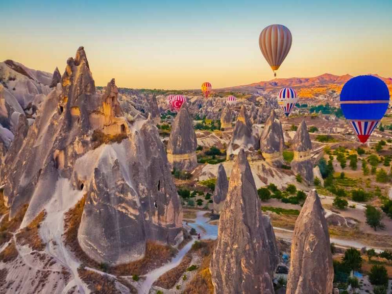
HOT AİR BALLOON
Cappadocia is known around the world as one of the best places to fly with hot air balloons. The spectacular surrealistic landscapes combined with excellent flying conditions allow the balloons to gently drift over and between fairy chimneys, pigeon houses hewn into the unique rock formations, orchards and vineyards – through impressive valleys, each with distinctive rock formations, colors and features – and then float up over rippled ravines for breathtaking views over the region.
CAVUSIN
Cavusin old Greek village in the Cappadocia region of Turkey is rarely featured in travel articles. If it does appear, it garners a couple of sentences before the author talks about other more well-known places such as Goreme, the transport and accommodation hub.
It is separated into 2 parts; the new town and the old greek village and on my third visit to Cappadocia, my tour guide recommended we change the itinerary for an hour to visit the 5th century church of Saint John the Baptist, situated in the old village part.
Güllüdere (St. Agathangelus) Church
It is located in the far left draw of the Güllüdere valley about 2 km (1 mi) from the village of Çavuşin. It was founded at the mouth of the draw on top of a steep slope.
The design of the nave is square with a flat ceiling and it has a single broad apse. The apse was added in the 9th or 10th century to the main structure dating back to the 6th – 7th century. There are 2 or 3 layers of frescoes in the apse which indicates that it was painted regularly. Symbols of Gospel authors are drawn symmetrically and are sitting on the right and left of an enthroned Jesus.
In the middle of the flat ceiling is the relief of a cross in the middle of a circle surrounded with palm leaves and garlands. This sort of relief most likely belongs to the Iconoclastic period. The people of the area had a great love for the cross and it continued to be used as a motif after the Iconoclastic era because it symbolized the “Holy Cross” in Jerusalem.
At the Cavusin old town, the church of St. John the Baptist rises on top of the hill. The church was built in the 5th century and it is the biggest cave church of Cappadocia even though it was divided into three rooms in 10th century against danger of collapsing. Most of the frescoes of St. John the Baptist church are faded by smoke but there are still some visible ones. Its cathedral-like proportions are also astounding.
Cavusin (Nicephorus Phocas) Church: This barrel-vaulted church, with one nave and three apses, is situated 2.5km from Goreme on the Goreme-Avanos road. Its narthex is collapsed. The church was built around 964/965.
Scenes: On the vault are the Annunciation, Visitation, Proof of the Virgin, Flight into Egypt, Joseph’s Dream Ii, Blessing and Mission of the Apostles, Adoration of the Magi, Massacre of the Innocents, Pursuit of Elizabeth, Killing of Zacharias; on the west wall are Entry into Jerusalem, Raising of Lazarus, Healing of the Blind Man, Descent from the Cross, Women at the Tomb; on the wall of the apse the Transfiguration; on the north apse Emperor Nicaphorus Phocas and his family, which held power and authority in Cappadocia.